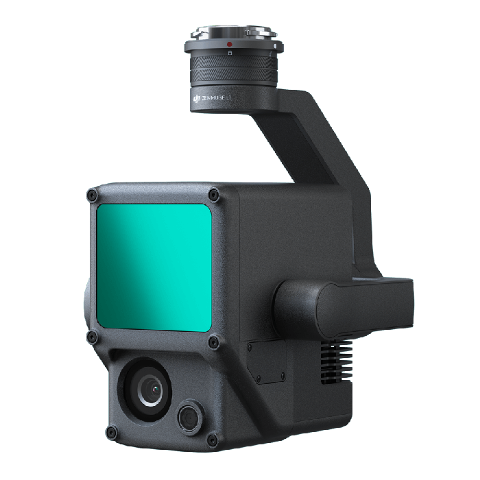
DJI Zenmuse L1
by DJIThe Zenmuse L1 integrates a Livox Lidar module, a high-accuracy IMU, and a camera with a 1-inch CMOS on a 3-axis stabilized gimbal. When used with Matrice 300 RTK and DJI Terra, the L1 forms a complete solution that gives you real-time 3D data throughout the day, efficiently capturing the details of complex structures and delivering highly accurate reconstructed models.
- Plaćanje na rate Plaćajte na rate Visa, Visa Premium, Maestro, MasterCard i Diners kreditnim karticama. Naknada je 5% na objavljenu cijenu a zaračunava se u košarici prilikom odabira plaćanja. Više detalja provjerite na linku Načini plaćanja.
- Brza dostava Za sve narudžbe unutar RH zaprimljene do 14h dostava će biti izvršena sljedećeg radnog dana*. Za cijelu Europu vršimo brzu dostavu, a više detalja provjerite na linku Načini dostave.
- Međunarodna kupnja EU tvrtke(osim RH) s valjanim VAT ID brojem plaćaju cijenu bez PDV-a. Cijena će se obračunati prilikom check out-a. Svi kupci izvan EU plaćaju izvoznu cijenu bez PDV-a.
- Frame Lidar with up to 100% effective point cloud results
- Detection Range: 450m (80% reflectivity, 0 klx) / 190 m (10% reflectivity, 100 klx)
- Effective Point Rate: 240,000 pts/s
- Supports 3 Returns [3]
- Line Scan Mode and Non-repetitive Scan Mode
- 20MP
- 1-inch CMOS
- Mechanical Shutter
- Accuracy: 0.025° (roll/pitch) / 0.08° (yaw)
- Vision Sensor for Positioning Accuracy
- GNSS, IMU, RGB Data Fusion
General
-
Product Name
-
Zenmuse L1
-
Dimensions
-
152×110×169 mm
-
Weight
-
Approx. 900 g
-
Power
-
30 W
-
IP Rating
-
IP44
-
Supported Aircraft
-
Matrice 300 RTK
-
Operating Temperature Range
-
-20° to 50° C (-4° to 122° F)
-
Storage Temperature Range
-
-20° to 60° C (-4° to 140° F)
System Performance
-
Detection Range
-
450 m @ 80% reflectivity, 0 klx;
190 m @ 10% reflectivity, 100 klx
-
Point Rate
-
Single return: 240,000 pts/s;
Multiple return: 480,000 pts/s
-
System Accuracy
-
Horizontal: 10 cm @ 50 m;
Vertical: 5 cm @ 50 m
-
Real-time Point Cloud Coloring Modes
-
True color; coloring by reflectivity; coloring by elevation
Lidar
-
Ranging Accuracy
-
3 cm @ 100 m
-
Maximum Returns Supported
-
3
-
Scan Modes
-
Repetitive line scan mode, non-repetitive petal scan mode
-
FOV
-
Repetitive line scan: 70.4°×4.5°;
Non-repetitive scan: 70.4°×77.2°
-
Laser Safety
-
Class 1
Inertial Navigation System
-
IMU Update Frequency
-
200 Hz
-
Accelerometer Range
-
±8 g
-
Angular Velocity Meter Range
-
±2000 dps
-
Yaw Accuracy
-
Real-time: 0.18°, Post-processing: 0.08°
-
Pitch / Roll Accuracy
-
Real-time: 0.03°, Post-processing: 0.025°
Auxiliary Positioning Vision Sensor
-
Resolution
-
1280×960
-
FOV
-
95°
RGB Mapping Camera
-
Sensor Size
-
1 inch
-
Effective Pixels
-
20 MP
-
Photo Size
-
4864×3648 (4:3); 5472×3648 (3:2)
-
Focal Length
-
8.8 mm / 24 mm (Equivalent)
-
Shutter Speed
-
Mechanical Shutter Speed: 1/2000 - 8 s
Electronic Shutter Speed: 1/8000 - 8 s
-
ISO
-
Video: 100 – 3200 (Auto), 100 – 6400 (Manual)
Photo: 100 - 3200 (Auto), 100 - 12800 (Manual)
-
Aperture Range
-
f/2.8 - f/11
Gimbal
-
Stabilized System
-
3-axis (tilt, roll, pan)
-
Angular Vibration Range
-
0.01°
-
Mount
-
Detachable DJI SKYPORT
-
Mechanical Range
-
Tilt: -120° to +30°; Pan: ±320°
-
Operation Modes
-
Follow/Free/Re-center
Data Storage
-
Raw Data Storage
-
Photo/IMU/Point cloud data storage
-
Point Cloud Data Storage
-
Real-time modeling data storage
-
Supported microSD Cards
-
microSD: Class 10 or UHS-1 rating or above; Max capacity: 256 GB
Post-processing Software
-
Supported Software
-
DJI Terra
-
Data Format
-
DJI Terra supports exporting standard format point cloud models:
Point cloud format: PNTS/LAS/PLY/PCD/S3MB format
Reconstruction model format: B3DM/OSGB/PLY/OBJ/S3MB format
- Novo