DJI Mavic 3 Multispectral with 2-Year Plan Auto-Activated Code
by DJI20MP 4/3 CMOS RGB camera
Four 5MP multispectral cameras
Sunlight sensor
RTK module for centimeter-level positioning
43-minute max flight time
- Ratenzahlung Sie können auf Raten mit den Visa, Visa Premium, Maestro, Master Card und Diners reditkarten zahlen. Die Gebühr beträgt 5% des offengelegenen Preises und wird im Warenkorb bei der Zahlungsauswahl gerechnet. Sie können mehr Details auf dem Link Zahlungsarten überprüfen.
- Schnelle Lieferung Für alle Lieferungen innerhalb Kroatiens, die bis 14.00 Uhr erhaltet werden, wird die Lieferung binnen einem Arbeitstag geliefert. Für die ganze Europa nehmen wir die schnelle Zustellung vor und mehr Details können Sie auf dem Link Lieferungsarten überprüfen.
- Internationaler Kauf Die EU-Firmen (außer die Republik Kroatien) zahlen den Preis ohne die Mehrwertsteuer mit dem gültigen VAT ID- Nummer. Der Preis wird bei Check-Out gerechnet. Alle Käufer außerhalb der Europäischen Union zahlen den Ausfuhrpreis ohne die Mehrwertsteuer.
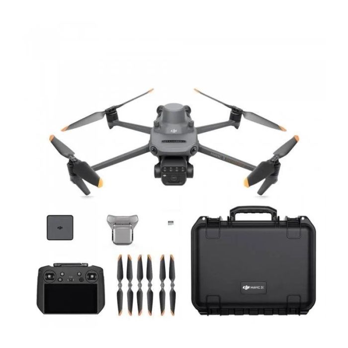
Paket beinhaltet
- x1 DJI Mavic 3M Aircraft with RTK Module & SD Card
- x1 Enterprise Care Basic 2 year
- x1 Remote Controller
- x3 Propeller Pair
- x1 Charger
- x1 Carrying Case
- x1 USB-C to USB-C Cable
- x1 Power Cable
- x1 USB-C Cable
- x1 Screwdriver
- x1 Manuals
- x1 DJI Terra Full-Featured 3-Month 1-Device(Gift)
Effective aerial surveying needs to see the invisible. That's why Mavic 3 Multispectral has two forms of sight. It combines an RGB camera with a multispectral camera to scan and analyze crop growth with total clarity. Agricultural production management requires precision and data, and Mavic 3M delivers both.
Highly integrated imaging system
Newly upgraded imaging system with one 20MP RGB camera and four 5MP multispectral cameras (green, red, red edge, and near infrared). Enables applications such as high-precision aerial surveying, crop growth monitoring, and natural resource surveys.
5MP Multispectral Camera
Near-infrared (NIR) 860 nm ± 26 nm
Red edge (RE) 730 nm ± 16 nm
Red (R) 650 nm ± 16 nm
Green (G) 560 nm ± 16 nm
RGB camera characteristics
4/3 CMOS - 20MP Image Sensor
1/2000s - Fastest mechnaical shutter speed
0/7s - High speed burst when RGB camera is used
Sunlight Sensor
The built-in sunlight sensor captures solar irradiance and records it in an image file, allowing for light compensation of image data during 2D reconstruction. This results in more accurate NDVI results, as well as improved accuracy and consistency of data acquired over time.
Accurate images that capture every pixel
Mavic 3M with RTK module for centimeter-level positioning. Flight control, the camera, and the RTK module sync in microseconds to accurately capture the location of each camera's imaging center. This enables Mavic 3M to do high-precision aerial surveying without using ground control points.
Efficient and reliable battery life
43 minutes Cruise Time
200 hectare - A single flight can complete mapping operations over an area of 200 hectares.
100W Battery Charging Hub | High-efficiency fast charging
88W fast charging | Aircraft
Stable signal, smooth image transmission
The O3 transmission integrates two transmitting signals and four receiving signals to support 15km ultra-long transmission distances.
Omnidirectional obstacle sensing, terrain-follow aerial surveying
The aircraft features multiple wide-FOV vision sensors that accurately detect obstacles in all directions for omnidirectional obstacle avoidance. The terrain-follow aerial surveying can be easily performed in steep-slope landscapes.
Orchard mapping
Mavic 3M allows terrain-follow aerial surveying of orchards, even on sloped landscapes. Together with DJI Terra or DJI SmartFarm Platform to reconstruct high-resolution orchard maps, automatically identify the number of trees, distinguish trees from other obstacles or objects, and generate three-dimensional operation routes for agricultural drones, making operations safer and more efficient.
Guide variable rate applications
For rice fertilization, cotton growth regulation, and potato foliar fertilizer spraying, the Mavic 3M is used to obtain multi-spectral images of crops. DJI Terra or the DJI SmartFarm Platform can then generate NDVI and other vegetation indices maps, capturing differences in crop potential and generating prescription maps that allow agricultural drones to execute variable-rate application. This ultimately allows users to reduce costs, increase yield, and protect the environment.
Intelligent field scouting
The Mavic 3M can carry out automatic field scouting. The field scout images can be uploaded to the DJI SmartFarm Platform in real time through a 4G network. It can find abnormalities, such as emergence deficiencies, weed pressure, and crop lodging in a timely manner. It can also conduct intelligent analyses, such as cotton seedling identification and rice production testing, using AI identification for real-time sharing of crop growth information, guidance of agronomic activities, and easy management of 70 hectares of farmland by one person.
Environmental Monitoring and Natural Resources Survey
The Mavic 3M can also be used in environment and natural resource surveys, such as water enrichment monitoring, forest distribution surveys, urban green area surveys, and more.
| Aircraft | ||
| Takeoff Weight | Mavic 3: 895 g | |
| Mavic 3 Cine: 899 g | ||
| Dimensions (Folded/Unfolded) | Folded (without propellers) 221×96.3×90.3 mm | |
| (Length×Width×Height) | ||
| Unfolded (without propellers) 347.5×283×107.7 mm | ||
| (Length×Width×Height) | ||
| Diagonal Length | 380.1 mm | |
| Max Ascent Speed | 1 m/s (C mode) | |
| 6 m/s (N mode) | ||
| 8 m/s (S mode) | ||
| Max Descent Speed | 1 m/s (C mode) | |
| 6 m/s (N mode) | ||
| 6 m/s (S mode) | ||
| Max Flight Speed (at sea level, no wind) | 5 m/s (C mode) | |
| 15 m/s (N mode) | ||
| 21 m/s (S mode) | ||
| Max Service Ceiling Above Sea Level | 6000 m | |
| Max Flight Time (no wind) | 46 minutes * | |
| Max Hovering Time (no wind) | 40 minutes * | |
| Max Flight Distance | 30 km | |
| Max Wind Speed Resistance | 12 m/s | |
| Max Tilt Angle | 25° (C mode) | |
| 30° (N mode) | ||
| 35° (S mode) | ||
| Max Angular Velocity | 200°/s | |
| Operating Temperature | -10° to 40° C (14° to 104° F) | |
| GNSS | GPS + Galileo + BeiDou | |
| Hovering Accuracy Range | Vertical: ±0.1 m (with Vision Positioning); ±0.5 m | |
| (with GNSS Positioning) | ||
| Horizontal: ±0.3 m (with Vision Positioning); ±0.5 m | ||
| (with High-Precision Positioning System) | ||
| Internal Storage | Mavic 3: 8 GB (available space is approx. 7.9 GB) | |
| Mavic 3 Cine: 1TB (available space is approx. 934.8 GB) | ||
| Hasselblad Camera | ||
| Sensor | 4/3 CMOS, Effective pixels: 20 MP | |
| Lens | FOV: 84° | |
| Format Equivalent: 24 mm | ||
| Aperture: f/2.8 to f/11 | ||
| Focus: 1 m to ∞ (with autofocus) | ||
| ISO Range | Video: 100-6400 | |
| Still Image: 100-6400 | ||
| Shutter Speed | Electronic Shutter: 8-1/8000 s | |
| Max Image Size | Main Unit: 5280×3956 | |
| Still Photography Modes | Single shot: 20MP Photos | |
| Automatic Exposure Bracketing (AEB): 20 MP, 3/5 bracketed frames at 0.7 EV | ||
| Burst shooting: 20 MP, 3/5/7 | ||
| Timed: 20 MP, 2/3/5/7/10/15/20/30/60 s | ||
| Video Resolution | Apple ProRes 422 HQ | |
| Apple ProRes 422 | ||
| Apple ProRes 422 LT | ||
| 5.1K: 5120×2700@24/25/30/48/50fps | ||
| DCI 4K: 4096×2160@24/25/30/48/50/60/120*fps | ||
| 4K: 3840×2160@24/25/30/48/50/60/120*fps | ||
| H.264/H.265 | ||
| 5.1K: 5120×2700@24/25/30/48/50fps | ||
| DCI 4K: 4096×2160@24/25/30/48/50/60/120*fps | ||
| 4K: 3840×2160@24/25/30/48/50/60/120*fps | ||
| FHD: 1920×1080@24/25/30/48/50/60/120*/200*fps | ||
| Max Video Bitrate | H.264/H.265 Bitrate: 200 Mbps | |
| Apple ProRes 422 HQ Bitrate: 3,772 Mbps | ||
| Apple ProRes 422 Bitrate: 2,514 Mbps | ||
| Apple ProRes 422 LT Bitrate: 1,750 Mbps | ||
| Supported File Formats | exFAT | |
| exFAT | ||
| JPEG/DNG (RAW) | ||
| Video Formats | Mavic 3: | |
| MP4/MOV (MPEG-4 AVC/H.264, HEVC/H.265) | ||
| Mavic 3 Cine: | ||
| MP4/MOV (MPEG-4 AVC/H.264, HEVC/H.265) | ||
| MOV (Apple ProRes 422 HQ/422/422 LT) | ||
| Tele Camera | ||
| Sensor | 1/2-inch CMOS | |
| Shutter Speed | Electronic Shutter: 2-1/8000 s | |
| Lens | Lens | |
| Format Equivalent: 162mm | ||
| Aperture: f/4.4 | ||
| Focus: 3 m to ∞ | ||
| ISO Range | Video: 100-6400 | |
| Still Image: 100-6400 | ||
| Max Image Size | 4000×3000 | |
| Photo Format | JPEG/DNG (RAW) | |
| Video Formats | MP4/MOV (MPEG-4 AVC/H.264, HEVC/H.265) | |
| Still Photography Modes | Single shot: 12MP Photos | |
| Automatic Exposure Bracketing (AEB): 12 MP, 3/5 bracketed frames at 0.7 EV | ||
| Burst shooting: 12 MP, 3/5/7 | ||
| Timed: 12 MP, 2/3/5/7/10/15/20/30/60 s | ||
| Video Resolution | H.264/H.265 | |
| 4K: 3840×2160@25/30/50fps | ||
| FHD: 1920×1080@25/30/50fps | ||
| Digital Zoom | 4x | |
| Gimbal | ||
| Stabilization | 3-axis motorized (tilt, roll, pan) | |
| Mechanical Range | Tilt: -135° to 100° | |
| Roll: -45° to 45° | ||
| Pan: -27° to 27° | ||
| Controllable Range | Tilt: -90° to 35° | |
| Pan: -5° to 5° | ||
| Max Control Speed (tilt) | 100°/s | |
| Angular Vibration Range | ±0.007° | |
| Sensing | ||
| Sensing System | Omnidirectional binocular vision system, supplemented with an infrared sensor at the bottom of the aircraft | |
| Forward | Measurement Range: 0.5-20 m | |
| Detection Range: 0.5-200 m | ||
| Effective Sensing Speed: Flight Speed ≤ 15m/s | ||
| FOV: Horizontal 90°, Vertical 103° | ||
| Backward | Measurement Range: 0.5-16 m | |
| Effective Sensing Speed: Flight Speed ≤ 12m/s | ||
| FOV: Horizontal 90°, Vertical 103° | ||
| Lateral | Measurement Range: 0.5-25 m | |
| Effective Sensing Speed: Flight Speed ≤ 15m/s | ||
| FOV: Horizontal 90°, Vertical 85° | ||
| Upward | Measurement Range: 0.2-10 m | |
| Effective Sensing Speed: Flight Speed ≤ 6m/s | ||
| FOV: Front and Back 100°, Left and Right 90° | ||
| Downward | Measurement Range: 0.3-18 m | |
| Effective Sensing Speed: Flight Speed ≤ 6m/s | ||
| FOV: Front and Back 130°, Left and Right 160° | ||
| Operating Environment | Forward, Backward, Left, Right, and Upward: Surface with a clear pattern and adequate lighting (lux>15) | |
| Downward: Surface with a clear pattern and adequate lighting (lux >15). Diffuse reflective surface with diffuse reflectivity>20% (e.g. wall, tree, person) | ||
| Video Transmission | ||
| Video Transmission System | O3+ | |
| Live View Quality | Remote Controller: 1080p@30fps/1080p@60fps | |
| Operation Frequency | 2.400-2.4835 GHz | |
| 5.725-5.850 GHz | ||
| Max Transmission Distance (unobstructed, free of interference and aligned with controller) | 2.400-2.4835 GHz; 5.725-5.850 GHz | |
| FCC: 15 km | ||
| CE: 8 km | ||
| SRRC: 8 km | ||
| MIC: 8 km | ||
| Signal Transmission Ranges (FCC) | Strong Interference (urban landscape, limited line of sight, many competing signals): Approx. 1.5-3 km | |
| Medium Interference (suburban landscape, open line of sight, some competing signals): Approx. 3-9 km | ||
| Low Interference (open landscape abundant line of sight, few competing signals): Approx. 9-15 km | ||
| Max Download Bitrate | O3+: | |
| 5.5MB/s (with RC-N1 remote controller) | ||
| 15MB/s (with DJI RC Pro remote controller) | ||
| Wi-Fi 6: | ||
| 80MB/s* | ||
| Latency (depending on environmental conditions and mobile device) | 130 ms (with RC-N1 remote controller) | |
| 120 ms (with DJI RC Pro remote controller) | ||
| Antennas | 4 antennas, 2T4R | |
| Transmitter Power (EIRP) | 2.4 GHz: ≤33 dBm (FCC); ≤20 dBm (CE/SRRC/MIC) | |
| 5.8 GHz: ≤33 dBm (FCC), ≤30 dBm(SRRC), ≤14 dBm(CE) | ||
| Battery | ||
| Capacity | 5000 mAh | |
| Voltage | 15.4 V | |
| Charging Voltage Limit | 17.6 V | |
| Battery Type | Li-ion 4S | |
| Energy | 77 Wh | |
| Weight | 335.5 g | |
| Charging Temperature | 5° to 40° C (41° to 104° F) | |
| Battery Charger | ||
| Input | 100-240 V AC, 47-63 Hz, 2.0 A | |
| USB-C Output | USB-C: 5.0 V⎓5.0 A/9.0 V⎓5.0 A/12.0 V⎓5.0 A/15.0 V⎓4.3 A/20.0 V⎓3.25 A/5.0~20.0 V⎓3.25 A | |
| USB-A output | ||
| USB-A: 5 V⎓2 A | ||
| Rated Power | 65 W | |
| Charging Hub | Input | |
| USB-C: 5-20 V⎓5.0 A max | ||
| Output | ||
| Battery: 12-17.6 V⎓5.0 A max | ||
| Rated Power | ||
| 65 W | ||
| Charging Type | Charges three batteries in sequence. | |
| Charging Temperature Range | 5° to 40° C (41° to 104° F) | |
| Car Charger | Input | |
| Car Power Input: 12.7-16 V⎓6.5 A, rated voltage 14 V DC | ||
| Output | ||
| USB-C: 5.0 V⎓5.0 A/9.0 V⎓5.0 A/12.0 V⎓5.0 A/15.0 V⎓4.3A/20.0 V⎓3.25 A/5.0~20.0 V⎓3.25 A | ||
| USB-A: 5 V⎓2 A | ||
| Rated Power | 65 W | |
| Charging Time | Approx. 96 minutes | |
| Charging Temperature Range | 5° to 40° C (41° to 104° F) | |
| Storage | ||
| Recommended microSD Cards | Lexar 1066x 64GB V30 A2 microSDXC | |
| Lexar 1066x 128GB V30 A2 microSDXC | ||
| Lexar 1066x 256GB V30 A2 microSDXC | ||
| Lexar 1066x 512GB V30 A2 microSDXC | ||
| SanDisk High Endurance 64GB V30 microSDXC | ||
| SanDisk High Endurance 128GB V30 microSDXC | ||
| SanDisk High Endurance 256GB V30 microSDXC | ||
| Kingston Canvas Go! Plus 64GB V30 A2 microSDXC | ||
| Kingston Canvas Go! Plus 128GB V30 A2 microSDXC | ||
| Kingston Canvas Go! Plus 256GB V30 A2 microSDXC | ||
| Kingston Canvas Go! Plus 512GB V30 A2 microSDXC | ||
| Samsung EVO Plus 512GB V30 A2 microSDXC | ||
| Samsung PRO Plus 256GB V30 A2 microSDXC | ||
| Samsung PRO Plus 512GB V30 A2 microSDXC | ||
| SSD Specs | Mavic 3: 8 GB (available space is approx. 7.2 GB) | |
| Mavic 3 Cine: 1 TB (available space is approx. 934.8 GB) | ||
| DJI RC-N1 Remote Controller | ||
| Remote Controller Transmission System | a. DJI Mini 2/ DJI Mavic Air 2: O2 | |
| b. DJI Air 2S: O3 | ||
| c. DJI Mavic 3: O3+ | ||
| Max Supported Mobile Device Size | 180×86×10 mm (Length×Width×Height) | |
| Operating Temperature | 0° to 40° C (32° to 104° F) | |
| Transmitter Power (EIRP) | 2.400-2.4835 GHz: | |
| <26 dBm (FCC), <20 dBm (CE/SRRC/MIC) | ||
| 5.725-5.850 GHz: | ||
| <26 dBm (FCC), <23 dBm (SRRC), <14 dBm (CE) | ||
| Battery Life | Without charging any mobile device: 6 hr; | |
| when charging mobile device: 4 hr | ||
| Supported USB Port Types |
Lightning, Micro USB, USB-C |
- Neu
- Neu
- Neu
- Neu