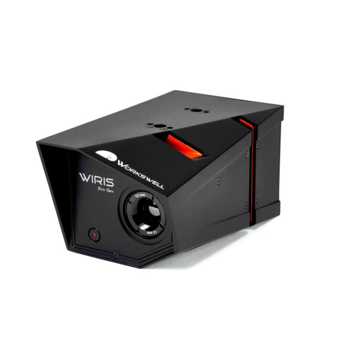
Workswell WIRIS Gen.2– thermal imaging camera for drones, 640 x 512 pixels, 13mm
by WorkswellWorkswell WIRIS Gen.2– thermal imaging camera for drones, 640 x 512 pixels, 13mm
- Plaćanje na rate Plaćajte na rate Visa, Visa Premium, Maestro, MasterCard i Diners kreditnim karticama. Naknada je 5% na objavljenu cijenu a zaračunava se u košarici prilikom odabira plaćanja. Više detalja provjerite na linku Načini plaćanja.
- Brza dostava Za sve narudžbe unutar RH zaprimljene do 14h dostava će biti izvršena sljedećeg radnog dana*. Za cijelu Europu vršimo brzu dostavu, a više detalja provjerite na linku Načini dostave.
- Međunarodna kupnja EU tvrtke(osim RH) s valjanim VAT ID brojem plaćaju cijenu bez PDV-a. Cijena će se obračunati prilikom check out-a. Svi kupci izvan EU plaćaju izvoznu cijenu bez PDV-a.
Sadržaj pakiranja
- Workswell WIRIS thermal imaging system
- Your chosen lens
- Calibration certificate
- USB Flash drive 32Gb
- HDMI cable
- Servo connectors (PWM)
- Power supply cable
- Software “Workswell CorePlayer” licence
- Hard transport case
Since the end of 2016, the second generation of Workswell labelled “WIRIS 2nd gen” has been available. Apart from its temperature range extended up to 1500°C(using a high temperature filter), the second generation of the Workswell WIRIS product offers the following functions:
- SBus
- CAN bus for DJI A2, A3 and GPS
- full integration to DJI M600
- A faster 10Hz GPS with a jack connector
- The new TIFF format for storage of images
- A possibility of controlling the equipment through TCP/IP
- Real time hours are significantly more accurate now
- Digital outputs for the autopilot and GPS synchronisation
- An integrated stabilised source for the RC receiver
- 4 openings for an easier installation on the gimbal
Fully radiometrics and temperature measurement
Remotely, it is possible to view and store fully radiometric and calibrated image data (images and video) – ie. records that retain all the information about the capturing parameters, which can be subsequently fully processed in the supplied software.
Digital ZOOM
If the task is to measure distant objects, then you will appreciate the digital zoom option. In the case of a digital camera, a zoom of up to 16x is available; in the case of a thermal camera then up to 14x (with the resolution 640×512).
Photogrammetry and 3D models
Images captured by the system are fully radiometric and contain information about GPS coordinates in the EXIF metadata of the files. Such images can be subsequently used to create a 3D model – with the aid of a specialized software (for instance Pix4D).
GPS
You can link the image temperature data with the value from an external GPS receiver. GPS data is saved into the EXIF part of the JPEG file and is available for use.
HDMI Wireless transfer
The video output for the WIRIS system is standard HDMI. When using for instance Connex the wireless transfer of an image up to the distance of 1 km is possible! On the standard screen on the control unit you can view the video output as well as all menus and the other system functions.
Calibration
Each Workswell WIRIS thermal imaging system is shipped fully calibrated and comes with a calibration certificate. The measurement precision of each WIRIS system is tested using reference black body sources over the whole range of measured temperatures.
Modes and alarms
Standard Infrared image
Standard mode allows users to set different color palettes, maximum and minimum temperature analysis, set automatic or manual temperature range and displays all the data on the operator’s controller on the ground.
Alarm (security) mode
Alarm mode allows users to set a temperature limit and see (find) only objects (places) with higher or lower temperature than is set, eventually temperatures between or above and below two limit values. This is the key mode for security and industrial applications. Maximum and minimum analysis is also available in this mode.
Digital camera mode
Digital camera mode allows the operator to see the area in the visible spectrum. Parallel view of digital camera enables better orientation in space and user can easy guide the drone above the desired location.
| Workswell WIRIS 640 | ||
|---|---|---|
| Thermal Imaging Camera | ||
| Resolution | 640 x 512 pixels | |
| FPA active sensor size | 1.088 x 0.8705 cm | |
| Temperature ranges | -25°C to +150°C -40°C to +550°C (optional +1 500°C on request) |
|
| Temperature sensitivity | 0.05°C (50mK) 0.03°C (30mK) available on request |
|
| Accuracy | ± 2% or ± 2°C (In high temperature range 0°C to +550°C) | |
| Spectral Range | 7.5 – 13.5 μm | |
| Calibration | Yes | |
| Detector type | Uncooled VOx microbolometer | |
| Lenses | Interchangeable and focusable, various field of view | |
| Available lenses | 18°, 32°, 45°, 69° | |
| Focus | Manual | |
| ital zoom | 1 – 14x continuous | |
| Digital Camera | ||
| Resolution | 1 600 x 1 200 pixels | |
| Focus | Fixed | |
| Digital zoom | 1 – 16x continuous | |
| Screen real-time information | ||
| Modes | IR mode, digital camera mode | |
| Multimode View (PiP) | Yes | |
| Max/Min/Center temp. | Automatic hot spot and cold spot detection, center point measurement | |
| Temperature Range | Automatic or manual | |
| Real time clock | Displayed on a screen and saved in every image | |
| Size of the memory | Real-time calculation of free memory on board | |
| Digital zoom | Up to 14x in thermal camera, up to 16x in digital camera | |
| Time to Non-uniformity correction (NUC) | Can be set time interval when the NUC will be done | |
| Information from GPS | Number of satellites, altitude, speed, GPS position | |
| Languages | English, French, Spanish, German and Czech | |
| Remote Control | ||
| Digital inputs / CAN bus for DJI M600Pro full control | 7x PWM digital inputs for complete control of WIRIS during the flight or using standard DJI controller for full control of all WIRIS functions | |
| SBus protocol | Supports up to 18 channels using only one single cable | |
| PWM trigger | By servo connectors (PWM) via UAV controller | |
| PWM power supply | Integrated power supply for RC transmitters (5 V) | |
| External trigger (TTL trigger) | Images: can be saved every 500 ms by trigger Video: start or stop recording by trigger |
|
| Digital outputs | Autopilot confirmation trigger and GPS synchronization | |
| Full menu navigation | By only 2 digital inputs (Up/Down – Ok/Cancel via UAV controller) | |
| Image recording | Saved by PWM, SBus or External (TTL) trigger | |
| Video recording | Can be start/stop by PWM, SBus or External (TTL) trigger | |
| Display mode switching | Can be changed by trigger through digital inputs | |
| Palette control | All 19 palettes can be changed via UAV controller during the flight | |
| Other controllable functions | Temperature range settings, Alarm mode (isotherms), Max/Min/Center point analysis, zoom, image capturing, video capturing, modes etc. | |
| Memory and Data Recording | ||
| Memory | Internal:32 GB (up to 80000 images or 200 minutes of video) External: recording directly on USB stick |
|
| Image recording | Radiometric image and digital JPEG image can saved by trigger Radiometric image format: JPEG or TIFF |
|
| Video recording | Radiometric video recording can be start/stop by trigger | |
| Periodic image capturing | Yes, adjustable interval between 1 to 60 s (IR and digital saved on trigger) | |
| GPS location info | GPS data is stored in EXIF when external GPS is connected | |
| Remote control | Data are recorded by PWM, SBus or External (TTL) trigger | |
| File management | Images and video from each flight are stored in separate folders | |
| File transfer | Selected folders are transferred to USB flash disk | |
| Measurement Functions | ||
| Measurement functions | Center spot, Hot/Cold spot detection, Peak Max/Min spot detection | |
| Alarm mode (isotherm) | Above, Below, Between, Above & Below | |
| Hot/Cold spot detection | Auto hot and cold spot detection with temperature values | |
| Alarm Mode (isotherm) | Above, Below, between, above & below | |
| Peak Max/Min detection | Measurement interval 1 to 100 s | |
| Temperature unit | Celsius, Fahrenheit, kelvin | |
| Emissivity correction | Adjustable in WIRIS directly or in Software | |
| Other corrections | Reflected ambient temperature, atmospheric temperature | |
| Software | ||
| Workswell CorePlayer | Images and video analyzing software tool | |
| Workswell ThermoFormat | Useful for massive processing of IR images | |
| Video Output | ||
| Interface | Standard HDMI (digital) | |
| Resolution | 1280 x 720px, 1024 x 768px, 1024 x 600px, 800 x 600px | |
| Aspect ratio | 16:9 | |
| Other Connectivity | ||
| USB 2.0 | transferring data and updating the system via USB stick | |
| GPS (10 Hz) | NMEA protocol, TTL 5 V logic | |
| External GPS | GPS can be connected via Mavlink or CAN bus | |
| SBus | Supports up to 18 channels using only one single cable | |
| CAN bus (on request) | Yes, compatible with DJI A2 and A3, GPS image geotagging | |
| Mavlink | Yes, compatible with Pixhawk, GPS image geotagging | |
| Ethernet (on request) | TCP/IP control and data downloading | |
| Power Supply | ||
| Input Supply Voltage | 6 to 36 V DC | |
| Power dissipation | < 6W (max. 8W during calibration event of approx. 0.5 seconds) | |
| Power Connector | Coaxial 2.1 x 5.5 mm, outer shell – GND | |
| Dimensions/Weight | ||
| Dimensions | 135 x 77 x 69 mm | |
| Weight | < 390 g | |
| Mounting | 4x 1/4-20 UNC thread (2x bottom side and 2x top side) | |
| Operating Environment | ||
| Operating temperature | -15°C to +50°C | |
| Storage temperature | -30°C to +60°C | |
| Humidity | 5% to 95% non-condensing |

